
Real-time data from Newcastle upon Tyne makes the UK’s first smart street even smarter …
2 min read
… and will help create better living spaces for people
I talked last time about how Mosley Street in Newcastle upon Tyne was set to become the UK’s smartest street, just in time for the Great Exhibition of the North (GEOTN).
Working in partnership with Newcastle City Council, Newcastle University, Connexin, Mayflower and Quantela, we’ve attached IoT sensors to bins and street lamps to gather real-time data on bin capacity/waste management and lighting. We’re also monitoring traffic levels, air quality and parking on Mosley Street and nearby Neville Street with our Kinetic for Cities solution.
And that’s not all; we’re using artificial intelligence (AI) to build a predictive model that will assess the impact of traffic on road surfaces.
Watch my video, recorded at GEOTN, to find out more:
Here's @stuhiggins to talk about Mosley St – the UK's smartest street – and our work with @NewcastleCC! #NPHsummit #getnorth2018 pic.twitter.com/21ZaKMpnK5
— Cisco UK & Ireland (@CiscoUKI) July 6, 2018
In fact, we’ve been working with NCC for a while now, on projects aimed at developing better services for local people, and it feels as though it’s all come together in Mosley Street, which demonstrated its smart aspirations back in 1879, when it became the first street in the world to install electric lighting.
Making the invisible visible
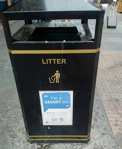
One of the UK’s smartest bins
The data streams gathered from Mosley Street and Neville Street are now live, with continual updates shown on boards across the city; you can also view them here:
Cisco.co.uk/smartstreet/solutions: real-time data on air quality, air temperature, bin capacity, parking availability and lighting status
Never have I been so excited about bins!
Cisco.co.uk/smartstreet: up-to-the-minute roads and traffic information, including data on bottlenecks and busiest streets.
This feed combines multiple data sets from IoT and non IoT sources, including data from Newcastle University’s Urban Observatory and satellite imagery – which is incredibly cool as well as being extremely useful.
And there is a serious purpose to all this work. Monitoring these activities in a real location – and providing visual representations of the data – will allow city leaders to monitor and review these existing services, in order to see where improvements can be made. This will benefit residents, workers and visitors.
For example:
- Data on waste can show which times/days bins fill up more quickly so that collections can be planned more efficiently, based on need. This can also help create cleaner, better spaces for people, as well as potentially cutting costs.
- Traffic flows and air quality monitoring will help NCC understand the extent of congestion levels and their environmental impact, helping it explore how to alleviate these issues.
- Predictive analytics for road surface wear and tear can estimate which roads require maintenance and when. This should help NCC plan ahead, reducing the disruption caused by emergency repairs and potholes.
Creating better living and working environments
Ultimately, it’s all about bringing together the digital and the physical to help city leaders create smarter, more efficient, healthier places for people to live, work and visit.
We’re looking forward to continuing our work in Newcastle-upon-Tyne, throughout the duration of GEOTN and beyond, as we explore more ways in which we can address the issues affecting urban and other communities across the UK and Ireland.
And we will continue to display live data across the city until the end of the event, making the invisible visible to as many people as possible We are also collecting this data to build not only a historical picture, but predictive models that will enable NCC can address problems before they occur.
As I said before, it’s all about making the invisible visible.
For information on our smart communities and local government portfolio, including Cisco Kinetic for Cities, visit our website or contact us directly.

